From Coordinates to position in Context: Where is Positioning Going
1. Introduction
This article grew from a practical question I kept asking in my own work. Land surveying is gaining new instruments, sensors, software, reality-capture systems, and increasingly large amounts of data. As these tools multiply, I began to wonder: What are we going to do with all of this information, and where is this path taking our profession?
That question led me beyond the instruments themselves and back toward the broader science behind positioning – GEODESY.
For centuries, surveyors have worked around a fundamental question:
Where am I?
And, for many mapping and surveying applications: How can I represent this piece of the Earth on a map?
The tools used to answer that question have changed dramatically.
A Gunter’s chain and compass established distance and direction. Optical instruments improved angular measurement, while electronic distance measurement transformed how distance was observed. Satellite techniques then extended positioning beyond local networks: Doppler satellite systems were followed by GNSS, while VLBI and SLR became fundamental techniques of modern space geodesy and global reference frames.
But these technologies are only part of the much broader science of GEODESY. Vanicek and Krakiwsky organize the fundamental tasks of geodesy around positioning, the Earth’s gravity field, and changes of the Earth with time. Modern geodetic practice reaches across geometric and physical geodesy, space techniques, reference frames, Earth dynamics, and other specialized areas. More recently, Chronometric Geodesy has shown how highly precise clocks can provide information about gravitational potential and height. [1] [2]
Land surveying is one important professional application within this larger geodetic framework. It applies measurement, reference systems, control, evidence, and professional judgment to practical questions on and near the Earth’s surface, while GEODESY provides the broader scientific foundation for understanding position, gravity, reference, and change.
As science advanced, broad disciplines divided into increasingly specialized branches, each developing its own methods, terminology, instruments, and areas of research. That specialization greatly expanded what we know. Now AI and machine learning may help us connect some of that specialized knowledge again – not by collapsing disciplines or replacing experts, but by helping professionals search across them, recognize relationships, reduce duplicated effort, and focus more deeply on the subject being investigated.
Geodesy is a good example. Reference frames, satellite observations, gravity, Earth dynamics, inertial measurements, reality capture, precise time, and quantum sensing rely on different physical principles, yet all can tell us something about the same fundamental question:
Where am I, and what is my relationship to the Earth and the reality around me?
The progression is remarkable. We have moved from the Gunter’s chain, angles, and optical observations to electromagnetic measurement, satellites, gravity, atomic-scale and quantum sensing, and even the relativistic behavior of time.
Today we have GNSS, inertial sensors, LiDAR, photogrammetry, reality capture, computer vision, terrain-aided navigation, gravimetry, magnetic-field sensing, highly precise clocks, atomic and quantum sensors, and increasingly capable computational tools.
Some methods determine Position directly. Others contribute indirectly by measuring motion, orientation, gravity, magnetic fields, time, or the surrounding physical environment. Some establish the reference framework within which Position has meaning. These direct and indirect measurements and observations can increasingly complement, constrain, validate, and provide context for one another.
Perhaps the next major advance will not come from a single new instrument or a single branch of geodesy, but from our ability to better understand and connect what these different observations are telling us.
That leads to the central question of this article:
What if the next evolution of Position is not simply greater coordinate accuracy – but greater context?
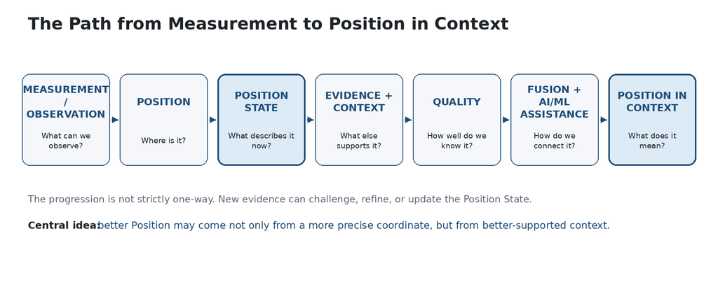
Figure 1 – The path from measurement to Position in Context. Conceptual diagram by the author.
2. How Do We Obtain Position?
GNSS is one of our most important positioning technologies, but it is not the only source of information that can contribute to Position.
For this discussion, it is more useful to classify observations by what they contribute. The same technology may serve more than one role.
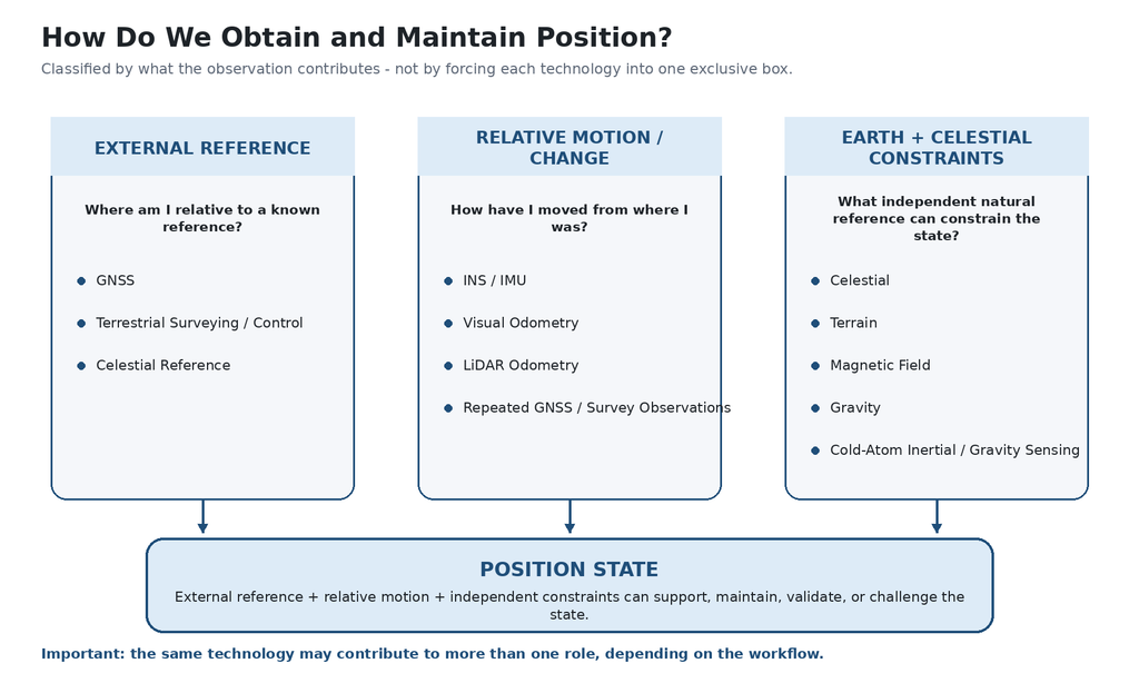
Figure 2 – Positioning observations classified by what they contribute. Categories can overlap. Conceptual synthesis informed by [1].
Position and Reference
Some observations connect an object to an external reference. GNSS can connect a position to a terrestrial reference frame. Terrestrial surveying can connect a point to geodetic or project control. Celestial observations can provide an independent natural reference. Terrain, magnetic, or gravity maps may also provide geographic constraints when suitable reference data exist.
Where am I relative to an external reference?
Relative Motion and Change
Other measurements and observations are especially useful for describing how Position changes from a known or previous state. INS/IMU, visual odometry, LiDAR odometry, and repeated GNSS or terrestrial measurements can all contribute relative information.
How have I moved from where I was?
Relative methods are essential for dynamic objects, but accumulated error can grow with time. That is why independent external measurements or observations are valuable: they can periodically constrain, check, or correct the estimated Position.
Earth and Celestial Constraints
The Earth and the celestial environment can themselves provide physical reference information:
- Stars and other celestial references
- Terrain and surface geometry
- Gravity and gravity anomalies
- Magnetic field and magnetic anomalies
- Earth rotation and inertial effects
- Visual and LiDAR features in the surrounding environment
The Earth and celestial references can become part of the positioning solution.
Four Examples of Where This Is Going
Celestial Navigation – Looking Beyond the Earth
Sodern’s Astradia is a daytime star tracker designed to aid inertial navigation in GNSS-denied conditions. Sodern lists 3 arcsec total XY precision (1σ) and 1 arcsec residual low-frequency XY error (1σ). Astradia provides attitude measurements rather than an XYZ position by itself; when coupled with an IMU, celestial observations can help constrain inertial drift. [4]
Magnetic Navigation – Using the Earth as a Geographic Reference
The Earth’s magnetic field can provide more than heading. Global field models such as the World Magnetic Model support magnetic direction and field information, while crustal magnetic anomalies can provide location-dependent signatures. EMAG2 is a global magnetic-anomaly grid compiled from satellite, ship, and airborne measurements. NOAA notes applications of global magnetic-anomaly grids where GPS is unavailable, but EMAG2 should be treated here as reference/research information rather than as a stand-alone operational navigation system. [6,8]
NGA’s MagQuest is important for a different reason: it is advancing how high-quality geomagnetic data are collected for future World Magnetic Model updates. In March 2026, three MagQuest CubeSats were launched to collect geomagnetic data for evaluation against WMM2025. The results are intended to inform a future global data-collection capability supporting WMM2030. MagQuest is therefore part of the magnetic-reference infrastructure that future navigation systems may depend on – not itself a vehicle navigation system. [7]
Cold-Atom Interferometry – Measurement at the Atomic Scale
Cold-atom interferometry uses the wave-like behavior of atoms to make highly sensitive measurements of quantities such as acceleration, rotation, gravity, and gravity gradients. These sensors do not need to produce a complete XYZ position to be valuable. In navigation, improved inertial or gravity-related observations can constrain part of the Position State and reduce dependence on external signals. The technology is progressing from laboratory research toward smaller and more rugged systems, but maturity and demonstrated performance vary substantially among applications and developers. [12-15]
Chronometric Geodesy – When Clocks Become Geodetic Sensors
Einstein’s theory of general relativity tells us that clocks located at different gravitational potentials do not run at exactly the same rate. Traditionally, geodesists used knowledge of the Earth’s gravity field to predict these small differences between clocks. Chronometric Geodesy reverses that relationship: if we can compare extremely precise atomic clocks at different locations, the measured difference in their frequencies can provide information about differences in gravitational potential. [2]
This creates an interesting connection to height. Modern atomic clocks have reached fractional-frequency accuracies near 10-18, and clock comparisons over long distances can correspond to gravitational-potential differences associated with height differences at approximately the centimeter level under suitable conditions. As a result, Chronometric Geodesy is beginning to complement established techniques such as geometric leveling and GNSS/geoid-based height determination. [2]
For a surveyor, the concept can be viewed simply: Two precise clocks at different locations -> compare their frequencies -> observe a gravitational-potential difference -> obtain additional information related to physical height.
The significance is not that atomic clocks will suddenly replace leveling, GNSS, or physical geodesy. Rather, time itself becomes another observable of the physical Earth. In the future, clock comparisons may provide an additional independent constraint that can be combined with conventional geodetic observations to improve our understanding of position, height, gravity, and their relationships. [2]
Not One Replacement, but Multiple Independent Observations
GNSS derives Position from satellite signal observations. Terrestrial surveying measures geometric relationships. Inertial sensors measure motion. Cameras and LiDAR sense surrounding geometry. Terrain can be matched to mapped surfaces. Celestial systems observe stars and other celestial references. Magnetic and gravity sensors detect physical fields of the Earth – information the observer cannot see directly with the human eye. Cold-atom and other quantum sensors may measure some of these physical quantities with exceptional sensitivity.
In this article, observation is used as the broad term for information obtained from a sensor or measurement process. Surveying may distinguish more specifically among direct measurements, observations, derived quantities, and supporting information. These methods do not provide the same information – and that is precisely why they can be valuable together.
The value of an observation is not determined only by whether it can produce a complete position. Its value may be in how it constrains, validates, or improves one part of the Position State.
In this article, I use observations as a broad term for information acquired from sensors or other sources, while recognizing that surveyors distinguish carefully between a measurement, an observation, and a derived result. When GNSS is strong, other measurements and observations can add validation and redundancy. When GNSS is degraded, they can help constrain and maintain Position. When GNSS is unavailable, combinations of independent measurements and observations may increasingly support navigation.
What combination of independent observations can help us establish, maintain, validate, and better understand Position?
And that brings us one step closer to Position in Context.
3. From Coordinates to Position
When we talk about Position on the Earth, two coordinate descriptions are especially familiar in geodesy: Earth-centered Cartesian coordinates (X, Y, Z) and geodetic coordinates (latitude, longitude, and ellipsoidal height). Both require a defined reference system. Astronomical observations historically provide another way to relate direction and position to the celestial sphere and the Earth’s rotation.
In modern GNSS surveying, however, a measured position already carries more information than three numbers. Depending on the workflow, we may know or record:
- Coordinate system / reference frame / geoid
- Date and time of observation
- Point identification / description / attributes
- Solution type and correction source
- Satellite geometry and quality indicators
- Horizontal and vertical precision
This information tells us what the coordinates mean, how they were obtained, and something about their quality.
Can other independent sources of information, when available, better support and explain that Position?
An inertial system can describe motion. A camera or LiDAR sensor can compare the observed environment with surrounding geometry. Terrain can provide a physical constraint. Celestial observations can provide a natural reference. Gravity and magnetic observations can relate the solution to physical characteristics of the Earth.
Position as a State
The word Position is sufficient for many static surveying applications. But a moving object needs more than a coordinate at one instant.
Position State = the information needed to describe the object at that moment.
For a static survey point, that may primarily be its position, reference, time, and quality. For a moving object, the state may also include velocity, orientation, acceleration, trajectory, and uncertainty.
Additional observations do not become part of the definition of Position itself. Instead, they can support, constrain, validate, or challenge the Position State.
From Position State to Position in Context
For this article, the distinction is simple:
- Position – Where is the object relative to a defined reference?
- Position State – What information is needed to describe the object at that moment? For a moving object, this may include position, velocity, orientation, time, and uncertainty.
- Position in Context – What relevant independent observations, records, and surrounding information help support, validate, or interpret that Position State?
The objective is not to attach more data to a coordinate, but to use relevant information to support, challenge, and better understand the Position State.
POSITION IN CONTEXT
What additional context could meaningfully support that Position State?
4. What Could “Position in Context” Include?
More information does not automatically mean a better position. Context is useful only when it is relevant, reliable, and capable of supporting, constraining, explaining, or challenging the Position State.
Geodetic Reference
What is it referenced to?
- Reference frame / datum
- Coordinate system
- Vertical datum / geoid
- Epoch
- Survey or geodetic control
Measurements and Observations
What observations support it?
- GNSS
- Terrestrial surveying
- INS / IMU
- Camera / LiDAR
- Terrain
- Celestial
- Gravity
- Magnetic
Physical Reality
What exists around it?
- Terrain
- Roads and structures
- Utilities
- Vegetation
- Mapped or captured features
Earth and Physical Fields
What does the physical Earth tell us?
- Gravity
- Magnetic field
- Earth rotation
- Terrain and deformation
- Gravitational potential / precise time
Survey and Land Relationships
How does it relate to the survey framework?
- PLSS – Township, Range, Section
- Survey control and monuments
- Parcels, Subdivisions
- Rights-of-way, Air Rights
- Easements
- Previous surveys, plats, and records
A geometric relationship to mapped land, record, or survey information is not automatically a legal boundary determination. Professional evaluation of the evidence remains essential.
Time
When does the information apply?
- Observation time
- Epoch
- Object motion
- Reference-frame motion
- Age of supporting data
Quality and Provenance
How well is it known, and where did the information come from?
- Accuracy and precision
- Uncertainty
- Source
- Collection date
- Processing history
- Reliability
Static and Dynamic Position States
Position in Context also depends on the object being positioned.
Static Position State → Where is the object?
Dynamic Position State → Where is the object now, how is it oriented, how is it moving, and where is it going?
A control point or monument is commonly treated as static for the purpose and time scale of a survey. A drone, aircraft, vehicle, vessel, robot, rocket, satellite, or moving survey platform has a dynamic state.
For a moving object, a precise observation of direction, orientation, rotation, acceleration, velocity, gravity, or another state variable can be valuable even if it does not independently provide XYZ coordinates.
Toward a Real-Time Position State
Today, not all supporting information can be collected or evaluated in real time. Some data require separate sources, specialized instruments, or post-processing.
That is changing as sensors, communications, computing, AI/ML, and quantum technologies become more capable.
What is my position? What supports it? Do the observations agree? What has changed? How well do I know it right now?
The goal is not “all information all the time,” but the relevant and sufficiently reliable information available at that moment.
Position in Context = Position State + Relevant Independent Evidence + Relevant Context
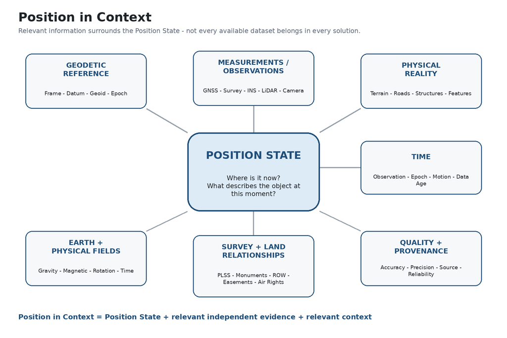
Figure 3 – Position in Context. The Position State is supported and interpreted through relevant reference, observations, physical reality, time, quality, and survey/land relationships. Conceptual diagram by the author.
5. How Well Do We Know Our Position?
Knowing a position and knowing the quality of that position are not the same thing.
How accurate and precise are my coordinates?
For surveyors, the distinction between accuracy and precision is fundamental. Precision describes consistency or repeatability; accuracy describes how closely the result agrees with its accepted or reference value. A position can be highly precise without necessarily being accurate.
Do independent observations agree with – and independently support – the position?
As more observations contribute to a Position State, consistency and independence become part of quality. A sensor can be precise and still be wrong, and several sensors can agree while sharing the same error source.
For a static survey point, quality may emphasize control, accuracy, redundancy, network geometry, adjustment results, repeatability, epoch, and stability. For a dynamic object, quality may also involve velocity, attitude, trajectory, time, and uncertainty.
Independent Observations and Confidence
A moving object may begin from a well-established externally referenced position. Relative motion then carries the state forward, while independent Earth- and celestial-referenced measurements, together with observations of the surrounding physical environment, can periodically constrain or challenge it.
GNSS available → other observations add validation, redundancy, integrity, and context.
GNSS degraded → other observations help constrain and maintain the state.
GNSS unavailable → combinations of independent observations may collectively support navigation.
Quality is not always a single number – it depends on the application and on how well the relevant parts of the Position State are supported.
Independence matters. Quality matters. Reference matters. Professional judgment still matters.
6. From Multiple Observations to an Integrated Position State
How do we bring multiple measurements and observations together?
Combining observations is not new to surveying or geodesy. What is changing is their number, diversity, speed, and physical nature.
From Adjustment to Sensor Fusion
- Least-Squares Adjustment – familiar in surveying and geodesy
- Dynamic estimation methods – used to update a moving state as new observations arrive
- Sensor Fusion – combines information from different sensors and sources
The mathematics can become sophisticated, but the principle is familiar: understand the observations and their quality, evaluate agreement, and estimate the most defensible state.
External Position + Relative Motion + Independent Constraints → Adjustment / Estimation / Fusion → Updated Position State
Not All Observations Deserve the Same Weight
A degraded GNSS solution should not influence the state as if its quality were unchanged. The same is true for an unreliable LiDAR match, an outdated terrain model, or magnetic reference data that are too coarse for the application.
The value of an observation depends on what it measures, how reliable it is, how independent it is, and whether it is relevant at that moment.
Agreement Is Valuable – Disagreement May Be More Valuable
Independent observations can check one another. If one source disagrees with several others, the answer is not automatically to average everything together. The disagreement may reveal a sensor problem, an outdated model, a changed environment, or an error in the estimated state.
Where Does AI Enter?
Established geodetic and estimation methods remain fundamental. AI and machine learning can work alongside them by helping to recognize features, match observations to maps or reality, detect abnormal behavior, classify conditions, retrieve relevant spatial information, and evaluate patterns across large datasets.
AI/ML may also predict an expected state or observation from previous motion and context, which can then be compared with the next physical observation.
AI can help Recognize → Predict → Compare → Evaluate.
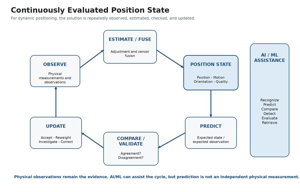
Figure 4 – A continuously evaluated Position State. New observations update the state, while prediction and comparison help identify agreement, disagreement, and changing quality. Conceptual diagram by the author.
A prediction can be useful for continuity, anomaly detection, and comparison, but it is not an independent physical observation. That distinction is essential when evaluating the evidence supporting a Position State.
From Sensor Fusion to Context-Aware Positioning
Sensor fusion combines measurements to improve a navigation state. Position in Context extends the idea to relevant maps, models, physical reality, time, quality, provenance, and records.
Sensor Fusion → Information Fusion → Context-Aware Positioning
For static positions, this may mainly improve validation, documentation, traceability, and interpretation. For dynamic positions, integration becomes central to maintaining a defensible state while the object moves and the available observations change.
What evidence supports where I am, how independent is it, how well does it agree, and how much should I trust my Position State right now?
7. Position, Records, and Professional Judgment
As positioning systems connect more information, the professional question becomes:
What does that information actually mean?
Measurement and Determination Are Not the Same Thing
GNSS can determine precise coordinates. LiDAR can capture dense three-dimensional geometry. Photogrammetry and SLAM can reconstruct the physical environment. AI can recognize features and relationships. But measurement alone does not always establish what a position means.
For a Professional Land Surveyor, a precise coordinate on a monument does not by itself determine whether that monument legally controls a property corner. That conclusion may require original survey evidence, monuments, record documents, occupation, rights, easements, rights-of-way, applicable law, conflicting evidence, and professional judgment.
Technology can provide more context. The Professional Land Surveyor determines what the evidence means when a professional surveying determination is required.
Position in Context and the Public Record
Position in Context could also improve how surveying and geospatial records are classified, organized, discovered, and used. Valuable information is distributed among county, state, federal, and other public repositories, often in different systems and formats.
As records become increasingly digital and spatially referenced, they could be organized not only by document name or recording number, but also by location, time, type of evidence, reference system, quality, and provenance.
A measured position itself could become a gateway to relevant available records.
What survey records are available here? What monuments or control were observed nearby? What plats, rights-of-way, easements, or other public records may be relevant?
With appropriate standards, interoperability, and public access, county, state, and federal information could increasingly be discovered and presented to the surveyor in the field and close to real time. AI could help classify records, extract spatial relationships, connect related documents, and identify potentially relevant evidence.
Retrieval is not determination.
The system could help the surveyor find and organize evidence much faster, while the Professional Land Surveyor evaluates its reliability, legal significance, conflicts, and applicability.
Position could become not only a description of where something is, but also a key for discovering what is already known about that location.
More Automation, More Focus
AI may reduce time spent searching, sorting, and repeatedly processing information, leaving more time for interpretation, verification, investigation, judgment, and discovery.
Technology can tell us more about where something is. Professional knowledge helps determine what that position means.
8. Conclusion – Where Is Positioning Going?
Where am I?
The question has remained simple while our tools have changed dramatically – from chains and optical instruments to satellites, GNSS, reality capture, precise clocks, quantum sensors, and increasingly capable computation.
We have become extraordinarily good at determining coordinates. Perhaps the next step is learning how to connect those coordinates more effectively with everything else we can observe.
From Static Position to Dynamic Position State
For a static survey point, the objective may remain familiar: establish a reliable position within a defined reference framework and document its quality. For drones, aircraft, autonomous vehicles, vessels, robots, satellites, rockets, and moving sensor platforms, the initial position is only the beginning.
For a moving object, Position is not simply a point. It is a continuously changing state.
From One Method to Multiple Sources of Evidence
Different technologies contribute different evidence: external reference, relative motion, physical reality, and Earth- or celestial-based constraints.
Different observations do not need to do the same job to be valuable together.
From Position to Knowledge About Place
A position observed in the field could increasingly become a gateway to survey control, monument records, plats, rights-of-way, easements, previous surveys, imagery, LiDAR, terrain information, and other available public records.
What do we already know about here?
A Broader Research Ecosystem
Reviewing these technologies also shows how strongly modern positioning research depends on cooperation among government agencies, universities, national laboratories, established aerospace and geospatial companies, and startups. The United States is a major center of this work – from GNSS and geodetic infrastructure to quantum sensing, magnetic navigation, autonomous systems, and resilient PNT – while important advances are also coming from Europe, Canada, Australia, and other parts of the world. The larger point is not national competition alone; it is the scale of scientific and engineering effort now being directed toward understanding and maintaining Position when one source of information is no longer enough.
Where Does the Path End?
The future of positioning may not be defined by one instrument, one sensor, one branch of geodesy, or one AI system. It may be defined by our ability to connect different, sufficiently independent observations of the same physical reality – and to understand the quality and meaning of those connections.
Physical observations remain the evidence. Geodesy provides the reference. Adjustment and estimation help combine observations, while AI can assist with recognition, prediction, comparison, organization, and evaluation.
Where am I, relative to what, what independent evidence supports that position, how well do I know it, and what does that position mean in the reality around me?
POSITION IN CONTEXT
Acknowledgment
I would like to thank Jan Van Sickle for bringing the subject of Chronometric Geodesy to my attention during the LinkedIn discussion that preceded this article and for pointing me toward the referenced literature. His suggestion led me to explore the subject and include it in this discussion. The broader perspectives presented here developed from my exploration of where positioning may be going.
References
[1] Vaníček, P., & Krakiwsky, E. J. Geodesy: The Concepts, 2nd ed. North-Holland / Elsevier, 1986.
[2] Delva, P., Denker, H., & Lion, G. “Chronometric Geodesy: Methods and Applications.” In Relativistic Geodesy: Foundations and Applications, Springer, 2019, pp. 25-85. DOI: 10.1007/978-3-030-11500-5_2. Read online
[3] NOAA National Geodetic Survey. “Datums and Reference Frames.” National Spatial Reference System / NGS.
[4] Sodern. “Astradia – Daytime Star Tracker for GNSS-Denied Navigation” and “Celestial Navigation on Earth.” Technical materials, 2025-2026. Read online
[5] Honeywell Aerospace Technologies. “Celestial Aided Navigation” and Alternative Navigation technical materials, 2025-2026. Read online
[6] NOAA National Centers for Environmental Information. “Earth Magnetic Anomaly Grid 2 (EMAG2 / EMAG2v3).” Read online
[7] National Geospatial-Intelligence Agency (NGA). “NGA’s MagQuest Advances with Upcoming CubeSat Launch.” March 29, 2026. Read online
[8] NOAA National Centers for Environmental Information. “World Magnetic Model (WMM).” WMM2025, valid through late 2029. Read online
[9] SandboxAQ. “AQNav” and supporting magnetic-navigation technical/flight-test materials, 2024-2026. Read online
[10] Leidos. “How the Earth’s Magnetic Field Could Help Navigate When There’s No GPS” and related Transition of Quantum Sensing materials, 2025-2026. Read online
[11] Q-CTRL. “Positioning, Navigation, and Timing” / Ironstone Opal GPS-free quantum navigation materials, 2026. Read online
[12] Ravagnin, M. Cold Atom Interferometry Sensors – Physics and Technologies: A Scientific Background for EU Policymaking. Publications Office of the European Union, 2020. DOI: 10.2760/315209. Read online
[13] AOSense, Inc. Cold-atom inertial, gravity, and time/frequency sensor research and development materials. Read online
[14] Infleqtion. Quantum-Enhanced Inertial Navigation / atom-interferometry navigation materials, 2024-2026.
[15] QinetiQ. “How Quantum Could Make Navigation More Resilient.” PNT series, July 10, 2026. Read online
[16] NOAA National Geodetic Survey. “Modernizing the National Spatial Reference System” and New Datums documentation, 2026.
Share:
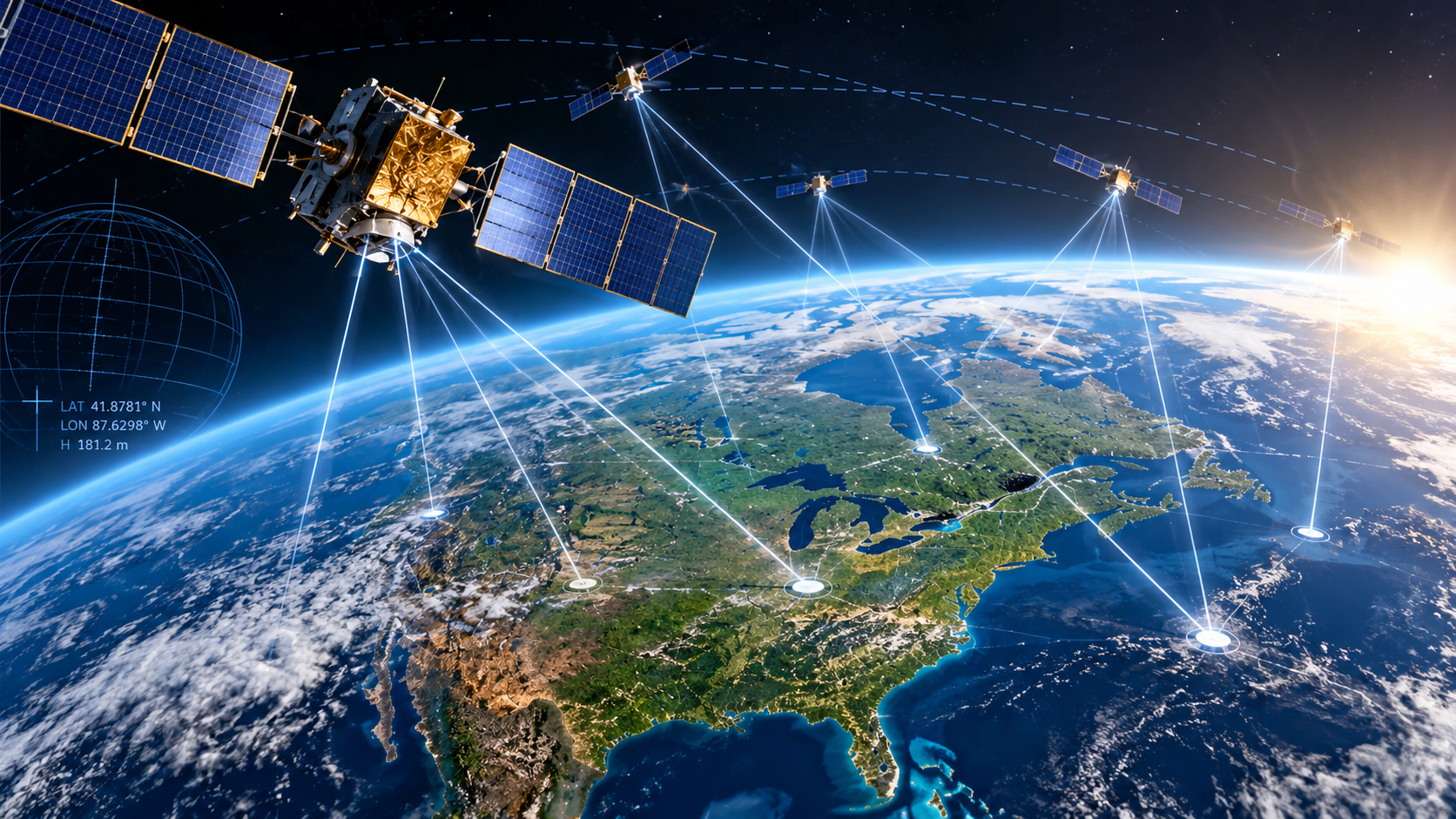
Father of GPS: Brad Parkinson — IEEE Medal of Honor 2018
October 15, 2026
Discover the contributions of Dr. Bradford Parkinson, widely recognized as the Father of GPS, and how satellite positioning transformed modern surveying and navigation.
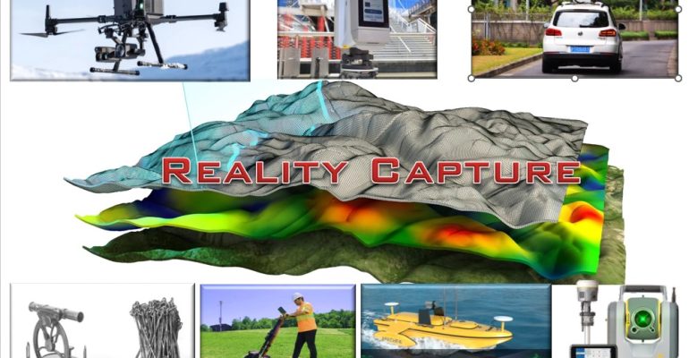
Precision remains the foundation — innovation builds on it
January 13, 2026
Surveying Meets the Future: Photogrammetry, LiDAR, Gaussian Splatting, and NeRF.